 M y - s t o r y - o f - a n - e v e r t o n i a n .
Asia Tsunami Disaster
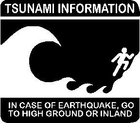
The sign is pretty obvious isnt it? Well, Boxing Day and look what has happened..This Asian Tsunami Disaster swept through several coastlines as well as lifes..Just yesterday one might just be enjoying with the entire family on the dining table for a good XMas Dinner and the day after, half the people that was on the table might have well been swept away from this disaster. Just a couple of weeks ago, 110 long-finned pilot whales and 10 bottle-nosed dolphins have been found dead after beaching themselves on Australia's island state of Tasmania. The Marine Biologist experts was not certain what causes whales and other ocean mammals to beach themselves and perhaps, just perhaps from my opinion that this could have very well been the first sign of this whole disaster..Sharks are guided by heat and Pilot Whales are guided by Deep Water Currents aka Thermohaline Circulation (I did some research). Oh Well..It might be or it might not be..
Anyway, on the day of this disaster my day was fine, i actually was in Great Ocean Road where its right next to Indian Ocean. Freaky eh? Oh Well shite happens..Anyway, gathered some information from various sites..And here's what i gather with so far..
Tsunami comes from the Japanese tsu (harbor) and nami (wave). Tsunamis are often incorrectly called tidal waves, but tides have nothing to do with them (though the damage may be worse if a tsunami hits at high tide).
A tsunami (pronounced tsoo-nah-mee) is a wave train, or series of waves, generated in a body of water by an impulsive disturbance that vertically displaces the water column. Earthquakes, landslides, volcanic eruptions, explosions, and even the impact of cosmic bodies, such as meteorites, can generate tsunamis. Tsunamis can savagely attack coastlines, causing devastating property damage and loss of life.
Tsunamis are unlike wind-generated waves, which many of us may have observed on a local lake or at a coastal beach, in that they are characterised as shallow-water waves, with long periods and wave lengths.
Recent tsunamis
1946: An earthquake in the Aleutian islands sent a tsunami to Hawaii, killing 159 people (only five died in Alaska).
1964: An Alaskan earthquake triggered a tsunami up to 20 feet tall that killed 11 people as far away as Crescent City, California and caused more than 120 deaths in all. More on the Web.
1983: 104 people in western Japan were killed by a tsunami spawned from a nearby earthquake.
1998: A Papua New Guinea tsunami killed roughly 3,000 people. A 7.1 magnitude earthquake 15 miles offshore was followed within 10 minutes by a wave some 40 feet tall. The villages of Arop and Warapu were destroyed.
Asia Tsunami
Asia Earthquake Explained

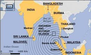
Indonesia is prone to seismic upheaval because of its proximity to the "Ring of Fire", an area around the Pacific Ocean basin where tectonic plates intersect and volcanoes erupt.

The quake occurred close to the island of Sumatra. Two tectonic plates, the Australian and Eurasian plates, meet just off Sumatra's south-west coast, grinding together and sending periodic seismic tremors through the region. At 0759 (0059 GMT) a violent rupture occurred on the sea floor along a fault about 1,000km long.

All along the rupture the seafloor was shunted vertically by about 10 metres. This movement displaced hundreds of cubic kilometres of the overlaying water, generating a massive tsunami, or sea surge. The wave then fanned out across the Indian Ocean at enormous speed.

The 9 magnitude quake, which was the strongest in the world for at least 40 years, wreaked havoc across the whole region. Walls of water, tens of metres high, slammed into coastal resorts thousands of miles apart. Surging seas and floods were reported as far away as east Africa.

Prayers to victims of this disaster
posted by ivan7 @ 1:34 am
2 comments
![]()


2 Comments:
The Islands of Indonesia are continuously rising
Soon after Tsunami, which killed more than two and a half lakhs of people and had originated from the island, Sumatra, it was found out that, after the earthquake the north western part of the island simeulue, which was in that region had risen about three feet high above sea level. On account of this, a new shore had formed on the north western part of the island. In addition to that; the sea sponges which were on the sea bed were visible above the sea level!
Three months after the earthquake on 26th December, 2004, another quake occurred on 28th March 2005 after which simeulue was found to be four feet above sea level. Apart from this, for an area of about three hundred kilometers, sea sponges which are normally found below the sea could be seen from all visible areas!
Why did the island rise four feet above sea level ?
As the molten rock keeps cooling gradually, the rocky plates that are formed at different levels are of less thickness and density and they keep rising continuously.
The main reason is that, when the molten rock cools, the water and hot gases get released and the rocky plates that are formed are of lesser thickness than the magma in which they formed. Water has a higher density and the ice cubes formed from it have a lower density and they tend to float on water Likewise, the molten rock material which has a higher density produces rocky plates which have a lower density and these move above sea level and form islands.
When new plates are produced by the molten rock material, they start moving upwards thereby pushing the plates which were already formed. The plates suddenly start rising upwards due to intense pressure.
Similar to the ripples that are formed and expanded when a plate of water is hit at the centre from below with a finger, when the island simeulue, which was found in the central part of the Indian Ocean suddenly rose up, the water was pushed aside in all directions and only this resulted in Tsunami.
The frequent occurrences of earthquakes and Tsunami in Indonesia are only due to the sudden rising of the islands.
But, the geologists have come up with a different explanation for the earthquakes which occur there. They say that, about six and a half crores of years ago, India was an island on the southern part of the equator. It moved slowly towards north and collided with Asia about five crores of years ago and it is still continuing its movement. The geologists also opine that due to this movement, when the indo-Australian plate suddenly went below the Burmese plate on December 26th, 2004, an earthquake occurred. There is no truth in what they say because even six and a half crores of years ago India had been part of Asia in the same place as it is found now.
The fossils of mammals which lived in Asia six and a half years ago have been excavated in the form of bones by Professor Ashok Sahani of Punjab University and Professor G.V.R. Prasad of Jammu University in the village of Naskal at Andhra Pradesh and they prove that the above statement is true. So, as per the researchers’ opinion, India had not been an island on the southern part of the equator about six and a half crores of years ago
So, it is proved that even six and a half crores of years ago India had been part of Asia in the same place as it is found now and is not moving in the north eastern direction. Therefore the indo-Australian plate did not go suddenly below the Burmese plate. So the earth quakes on 26 -12 -2004 and 28 – 3 -2005 and the Tsunami are only the result of the rising of the island, simeulue, above its original level.
Subject: Rising of the earth’s crust is responsible for producing earthquakes, Submission of report for publishing.
Earthquake is caused due to the movement of the land is a myth.
The most important thing that is missing in this view is that there is no explanation for why earthquake occurs in the centre of the land instead of the peripheral area. Actually the land is rising in different places. This is the reason why earthquakes occur only in the central parts of the land. To be specific, after an earthquake occurred on September 30th of 1993, in the village named Killari, it was found that the land had risen about three feet in height. This shows that the rise of the land is the cause of the earthquake.
‘Reasons for the Rise of the Earth’s Crust’
Earthquake is the effect of the rise of the land
On September 30th 1993, the earthquake that hit the village, killari, situated in central part of India resulted in the death of more than eight thousand people and raised the land surface about three feet high. This elevation was seen in an area of around two kilometers.
Why did the earthquake occur? The quake occurred only in killari, situated in central India and left two kilometers of land area raised. This proves that the earthquake occurred only due to the rise of the land.
Apart from this, the pictures taken by the satellite before the quake showed that the temperature of killari had also risen and the pictures taken after the quake showed it to be normal. After the earthquake occurred, on the borders of Andhra and Karnataka white colored smoke emitted from the ground.
Why did the land rise? Why was the temperature more? Why did the land emit white colored smoke?
We know that the molten rock material called magma is found inside the earth as we have seen it coming out through volcanoes. In the same way, when the molten rock, lava flows on the earth’s surface, we can see the condensed steam and other gases in the form of white colored smoke.
As the water and other hot gases are eliminated as steam, the molten rock cools down and turned in to rock. In the same way when the molten rock inside the earth starts cooling, water and Other hot gases come out in the form of white smoke. Due to this, the temperature of the land rises.
Moreover when the molten rock cools and as the water and hot gases get released, the rocky plates that are formed are of less thickness. For example: water has a higher density and the ice cubes formed from it have a lower density and float on water. Likewise, the molten rock material which has a higher density produces rocky plates which have a lower density and move above the level of the molten rock. In the same way, when new plates are produced by the molten rock material, they start moving upwards there by pushing the plates which were already formed. On account of this movement, the edges of the plates rub against each other thereby causing earthquakes.
For example, in 1356 an earthquake occurred in the city Basel in Switzerland which is situated in central Europe. In the same city, an organization which produces electricity using the heat from underground, drilled two holes of five meters each on the earth in the year 2006.
The project was to send cold water through the first hole which would be changed into steam using the heat of the molten rock and pushed out through the second hole and by rotating dynamos; this would be converted into electricity. But, on the eighth day after the water was sent inside the earth, in the same place, the Richter scale recorded an earthquake with an intensity of 3.4. Even if atom bombs are tested underground, earthquakes do not occur. How could the water which seeped inside produce an earthquake? This clearly shows that the water which seeped inside the earth cooled the molten rock which in turn formed new plates that rose up and caused the earthquake.
Volcanic activity in central Europe
Vogtland, which is situated in central Europe , had often been experiencing a number of minor earthquakes.
In the same place, a researcher by the name Dr,Karin brauer collected the bubbles which came out along with an underground spring in a marshy area and through his research, found out that gases were emitted from a volcano. Based on his research, he says that when the molten rock rises, the pressure of the gases increases and this results in the formation of cracks on rocks which may ultimately result in earthquakes.
But for millions of years in the past, these gases have been coming out of the earth. Apart from this, there are spaces for these gases to be eliminated. We have already seen this fact and the gases do not have enough pressure to bring about an earthquake.
A few years ago from the mountainous part of Nilgiris in India , smoke were seen emanating from earth, but fortunately no earthquake was caused. Likewise, Matsushiro in central Japan also experienced a number of mild quakes. To find out the reason for these quakes, a researcher by the name yoshida collected Water from the hot water springs found there and through experimentation discovered that the water was from the molten rock found underground.
So, she surmises that,” The water which is underground comes out with great pressure and this produces cracks on the rocky plates and this results in earthquakes”. But, the water and gases which are underground have been surfacing through the spaces found between the rocky plates for millions of years in the past. So, the reason for the continuous tremors and the elevation of land is only due to the slow rising of the rocky plates.
For example Wyoming found in central part of North America has more than three hundred hot water springs.
Due to the deposit of sulphur from the water, the rocks in that area appear yellowish in colour. So, the area of hot water springs is referred to as yellow Stone Park . Each year that place experiences about two thousand mild tremors. Between January, 2008 and March 2008, 287 tremors have rocked the place.
Moreover it has been found out through satellite research that the land area of 60 miles is continuously raising. To be specific, starting from 2004 till 2006, the land area has been rising at the rate of 2.8 inches every year and has risen to a height of seven inches in three years. It is still rising.But research scholars say that, it is only the effect of the expansion of the molten rock due to heat.
But the surfacing of the water only shows that the molten rock is cooling.
So the release of water and the gases from the molten rock cools the molten rock. This results in the formation of new plates and the rising in the land level in the central part of the continents and results in tremors in those areas only.
There will be an earthquake tomorrow
One week before an earthquake struck the city of haicheng on 30th February, 1975, on the north eastern part of China , it was officially announced that a quake would strike the city.
People abandoned their houses and assembled in an open area in the snow fall. For one week nobody did any work. As announced there was an earthquake of 7.3 magnitudes which was recorded on the Richter scale.
Two thousand and thirteen people lost their lives. It was estimated that if precaution had not been taken, the death toll would have exceeded one and a half lakhs! The whole world looked at China with surprise and when asked, they said that for the past one year slight tremors were occurring and they were gradually getting intensified. They also explained that, during the previous week there was tremendous change in the underground water table.
But, in the next year, the earthquake which struck the city of Tang Shan situated in the north eastern part of China killed two and a half lakhs of people and severely wounded more than one and a half lakhs of people.
The Chinese geologists said that on this occasion there were no preceding tremors. During the earthquake in haicheng, sulphur gas and in Tang Shan carbon-di-oxide were eliminated from underground. Regarding this incident, Carol Raymond is a geophysicist at NASA's, said “Only if we know how an earthquake is caused, we can warn about it in advance”.
How Does an Earthquake occur?
When the rocky plates under the ground rise and their edges rub with each other, an earthquake is caused. Moreover, the water and the gases found between them are under great pressure when these plates rise and so come above the surface of the earth.
Hence, it is understood that the hot gases and water which come out of the earth and the temperature changes are the most authentic warnings of an approaching earthquake. So, by closely and continuously monitoring the temperature changes through satellite observations and finding out the depth and temperature in which the molten rock is found in a particular place, the occurrence of an earthquake can be predicted in advance. Based on it, if precautions are taken, great loss to human life can be prevented.
Continents are not drifting, but rising...
In 1835, when scientist Charles Darwin came to Galapagos Island which is located at Pacific Ocean, thousand km far away from South America , he found giant tortoises. He was surprised to see the presence of the tortoise because each one would weigh around 250 kilo, which look like a rock and those tortoises couldn’t float in the sea even for a second.
According to the researchers, these tortoises might come from South America by floating by means of tree branches for two weeks when storm hit. But the tree branches can not float in the same dimension and it will roll and flow. Meantime, these tortoises have no fingers in their legs like elephants. And so, it is not possible for these animals to escape from falling in to the river, when the tree branches roll and flow... It is interrogated such as how this animal could survive for two week with out any food and water. The researchers explained that these animals have the ability to store the enormous fats and water in their body. So they manage to live for two week with out having any food and water.
Moreover, Trevor worth, one of the researchers, has taken the jaw and leg bones of a rat like animal which lived 10 million years ago in the New Zealand , An island which situated two thousand kilometers far away from Australia continent. This animal has a bulged structure on the upper part of the leg bone. So it is found that its locomotion was hopping like kangaroo. Therefore it is impossible for the animal to reach the island by floating tree branches, According to Michael archer, a paleontology researcher.
The researchers said that the tortoises had taken two weeks to reach the Galapagos Island , a thousand kilometer away from South America , by means of floating tree branches. Similarly, it would take at least four weeks far the rat to arrive New Zealand by means of floating tree branches, which is located two thousand kilometer away from Australia .
Could a small animal like rat live for a long period with out having any food and water? Then how the animal reached New Zealand ?
Hear the only possibility is extreme low sea level and exposed land connection, on which the animal migration took place, to reach Remote Island From the Australian continent. Moreover dinosaur’s bones were also found in the island called Chatham which is located near the New Zealand . Indicate the dinosaur’s migration also took place between the continents due to the low sea level of ten thousand feet.
But the presence of closely related dinosaur’s bones on different continents leads to think other researchers differently. They think that all the continents were once jointly present and later separated and drifting apart. But the ancient low sea level of ten thousand feet is the only possible reason for the spreading of ancient animals on other continents.
At the same time the presence of fossils of sea animals such as whales and ammonites indicates that all the continents were once lie under the sea and later rose above sea level. And this rising of land masses caused the earthquake. please visit the website, www.originofplanets.com
Contributing Writer Scientist, G. Ponmudi. Chennai I am working as a junior assistant in the health department. And my qualification is Bsc (zoology).
Dear editor,
I, Scientist G. Ponmudi humbly wish to inform you the following:
Why did the island of Java alone experience earthquake on 2009-09-02 ?
On 2009-09-02 the earthquake which was of 7.3 on the Richter scale and shook Java, one of the islands in the group of Indonesian islands, claimed 75 lives.
The explanation given by geologists is that, India and Australia are found on a huge rocky plate, which is moving in the northern direction and sliding below the rocky plate on which the group of Indonesian islands is situated and rubbing against it. This is the root cause of earthquakes.
But why did the island of Java alone experience earthquake on 2009-09-02 ?
Why didn’t the island of Sumatra or the island of Andaman experience earthquake on 2009-09-02 ?
How is it possible for the Indo-Australian rocky plate to slide only below the island of Java alone?
How is it possible for the Indo-Australian rocky plate to slide below different islands on different days?
What is the real reason behind the striking of earthquakes in different islands of the Indonesian islands on different days?
Volcanoes result in earthquakes.
There are one hundred and thirty volcanoes in the Indonesian islands.
When the molten rock material in these volcanoes cools down and hardens to form rocks, hot gases and water are released from it. This produces rocks of lesser density from high density molten rock.
A thing of lesser density will float in a liquid of higher density.
Hence, when the newly formed rocks of lesser density in the volcanoes below the Indonesian islands rise upwards their edges rub against the edges of the nearby rocky plates, resulting in earthquakes on that particular island alone.
Post a Comment
<< Home